Category:Friuli seismic regions
Jump to navigation
Jump to search
1348 earthquake in Italy | |||||
| Upload media | |||||
| Instance of | |||||
|---|---|---|---|---|---|
| Point in time |
| ||||
 | |||||
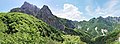
Friuli pictures were taken in the map marked by the blue line:
The area contains the Erto zone and its valley Val Zemola. This zone is located between the Duranno Mountain (north) and the Col Nudo Mountain (south) and is still an active seismic region.
The seismic centrals of Friuli are marked here as blue dots.
Media in category "Friuli seismic regions"
The following 16 files are in this category, out of 16 total.
-
 Bosco verso la Galvana.jpg 3,020 × 2,193; 2.3 MB
-
 Cima dei Preti da Forc. Lodina.jpg 3,072 × 2,304; 1.16 MB
-
 Friuli alpine river and village.jpg 1,024 × 687; 127 KB
-
 Friuli alpine village.jpg 1,024 × 687; 209 KB
-
 Friuli mountain top.jpg 2,048 × 1,536; 2.59 MB
-
 Friuli mountainous landscape.jpg 3,072 × 2,304; 1.41 MB
-
 Il corvo imperiale e lo stambecco.jpg 759 × 1,499; 241 KB
-
 Il Pissàndol della Val Zemola.jpg 1,547 × 4,133; 1.46 MB
-
 Il Pissàndol della Val Zemola2.jpg 2,041 × 2,800; 1.62 MB
-
 La Garofola.jpg 3,072 × 2,304; 2.92 MB
-
 Panorama alta Val Mesazzo.jpg 8,000 × 2,926; 5.88 MB
-
 Pascoli del Lodina e i Campanoz.jpg 3,072 × 2,304; 3 MB
-
 Rifugio Maniago dalle cime Centenere.jpg 3,072 × 2,304; 1.83 MB
-
 Stambecchi-Friuli.jpg 3,072 × 2,304; 1.56 MB
-
 Val de Forscia.jpg 2,741 × 1,940; 1.28 MB
-
 Val Zemola dalle Centenere.jpg 10,436 × 1,831; 3.34 MB


